Project Description
Vehicle fleet management is the ability to make the most of the available vehicles of a company or an organization by remotely monitoring the operation of vehicles by recording their location and other operating parameters in real time.
Through the recording and management systems, the movement of the vehicles is monitored remotely, as a result of which useful conclusions are produced regarding the traffic parameters (itineraries, speed, stops, temperatures, fuel consumption, door opening, etc.). This data is either utilized individually or entered directly into business resource management (ERP) systems in order to draw conclusions about the operation of a business and improve its business operation.
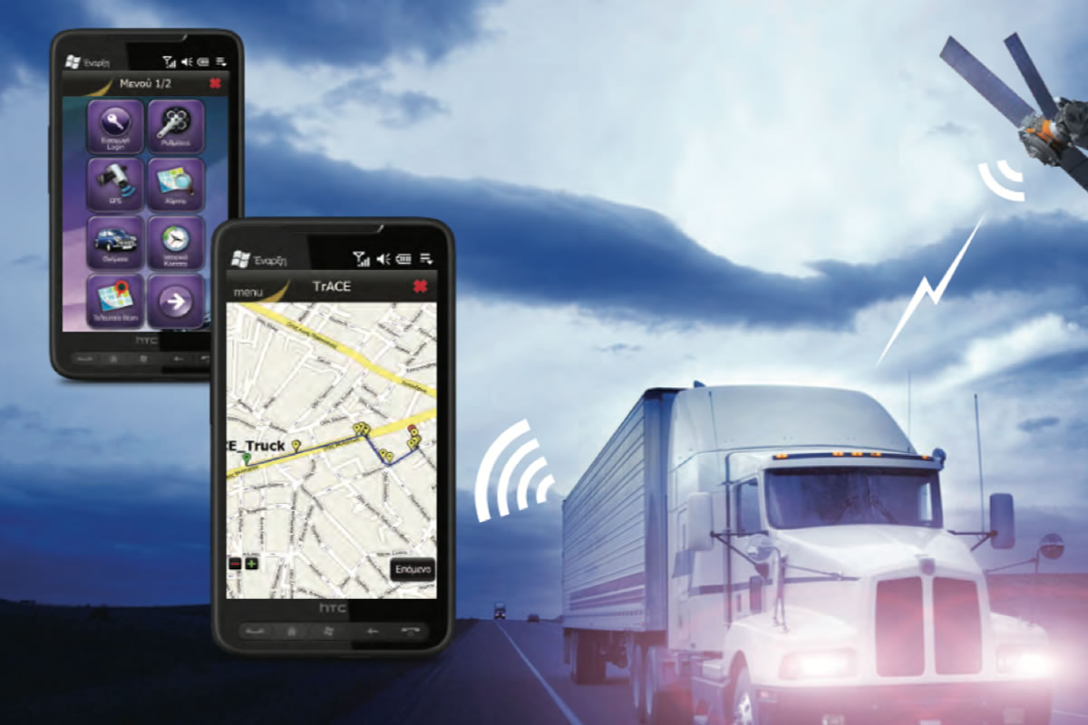
Mobile Fleet is a real-time, integrated information system for locating and managing vehicles of all types, ie trucks, passengers, cranes, earthmoving, etc., aimed at companies, organizations and individual users.
Mobile Fleet users have all the information about their vehicles (where they went, when, at what speed, how many stops they made, when they entered a specific geographical area, when they left, which customers they visited, how much fuel they consumed, what temperature, etc.) in real time but also through detailed or concise reports generated automatically by the system. All the above information is available either on the computer or on the mobile phone of the system users.
Today customers of the Mobile Fleet system are large companies and organizations from the field of transport, retail, insurance, lubricants, supermarkets, the wider public and private sector.
It has state-of-the-art technology, innovative technological features and capabilities that are truly impressive
It is installed easily and quickly
It does not require investment in additional computer equipment (in case of subscription use of the system) as well as installation of software on the user’s computers
Provides a friendly, simple and complete user interface, which adapts directly to what the user wants to monitor and manage
The display of vehicle traffic is done immediately, at intervals specified by the user, without annoying expectations
It is easily accessible from computers that have only a? WEB Browser? and Internet connection, so that this access can be accessed by authorized users wherever they are
The functions of the application are also available on mobile devices, such as Pocket PC and PDA phones for greater flexibility in the use of the system
It provides a direct choice between different digital cartographic backgrounds (maps), ie with conventional format, Google maps, etc., so that there is the possibility of uniform coverage of both Greece and most European countries
Automatically adjusts the communication profile, ie whenever data will be sent from the vehicle, when it moves inside or outside Greece, in order to effectively address the problem of roaming costs
It does not set limits on the number of users or how many vehicles will be managed by the system
The movement and condition of the vehicle
Its exact location
The recording of predetermined events (eg speeding, unauthorized use of the vehicle, etc.)
Monitoring of vehicle systems through sensors (eg switching on / off the engine, fuel control, etc.)
The available terminals to meet management needs are FM2100 and FM4100.
The communication of the control and signal reception center with the vehicles is continuous (On-line) through GPRS network of the mobile telephony. During this, the data of traffic and stops are taken (history of the route) and their registration in the database for their further processing by the program.
It is worth noting that even if the connection of the vehicle to the control and signal reception center is not possible in some areas, the geographical coordinates during the movement of the vehicle are recorded and stored in the telematics unit and sent as soon as the connection is established.
Also, it is optional to recognize events and send from the Telematics Unit installed in the vehicle and information about them via GPRS or SMS (Possibility to preset up to 24 addresses for sending SMS).
Multilingual environment
The user has the ability to select the language of the system, ie the menus and references of the system to be in Greek, English, German or another language by appointment.
Real-time monitoring
With Mobile Fleet the user has the ability to access the traffic data of vehicles in real time
Detailed cartographic background of Greece and Europe
The geographical information system includes a cartographic background of both Greece and most European countries.
Possibility to choose a cartographic background
The user with a simple gesture can choose the view of the cartographic background that best serves his needs.
Vehicle routing
With the Mobile Fleet system it is possible to determine the routing of vehicles at points of interest, e.g. customers, suppliers, etc. This achieves better control, saving time, fuel and resources for the business.
Illustration of clientele and points of interest by the user
The application allows users to enter, individually or as a whole, their own points of interest, ie customers, suppliers, refueling points, etc., in order to display them on the map and be able to monitor the movement of their vehicles and receive reports in relation to them. These points of interest can be categorized. There is also the possibility of mass registration from existing points of interest data.
Search for vehicles, roads, numbers and points of interest
Users can search the system for their vehicles and any road or point of interest included in the cartographic background.
Define allowed / restricted access zones; Geofencing
The system provides the possibility for users to define zones in which the movement of vehicles is either allowed or prohibited. These areas can be demarcated in a number of ways. Data relating to the movement of vehicles in these zones are recorded in special reports.
Anti-theft protection
The Mobile Fleet system provides complete anti-theft protection of the vehicle as it can work with an installed alarm system, providing automatic sending of a message to the Control Center or SMS to a customer-defined mobile phone.
Voice communication
If the telematics unit is portable, the driver may have direct voice communication with the Control Center and vice versa.
Call Center
With the Mobile Fleet system it is possible to connect the call center of the call center (Call Center) with the department that serves these calls.
Reports and Statistics
The Mobile Fleet system provides a set of comprehensive reports and traffic statistics for each vehicle or group of vehicles.
Emergency response
With proper programming, the telematics unit can send messages to the Control Center or SMS to a user-defined mobile phone, which can indicate:
-Increase engine or storage chamber temperature above the permissible limit
– Speeding limit exceeded
-Alarm Button by the driver.
-Vehicle collision
– Movement of the vehicle with the engine off
It has state-of-the-art technology, innovative technological features and capabilities that are truly impressive
It is installed easily and quickly
It does not require investment in additional computer equipment (in case of subscription use of the system) as well as installation of software on the user’s computers
Provides a friendly, simple and complete user interface, which adapts directly to what the user wants to monitor and manage
The display of vehicle traffic is done immediately, at intervals specified by the user, without annoying expectations
It is easily accessible from computers that have only a? WEB Browser? and Internet connection, so that this access can be accessed by authorized users wherever they are
The functions of the application are also available on mobile devices, such as Pocket PC and PDA phones for greater flexibility in the use of the system
It provides a direct choice between different digital cartographic backgrounds (maps), ie with conventional format, Google maps, etc., so that there is the possibility of uniform coverage of both Greece and most European countries
Automatically adjusts the communication profile, ie whenever data will be sent from the vehicle, when it moves inside or outside Greece, in order to effectively address the problem of roaming costs
It does not set limits on the number of users or how many vehicles will be managed by the system
The most important benefits of using Mobile Fleet are:
Automatic detection of vehicles we are interested in
Visualization of any information in the provided geographical model, without the need to change it when the vehicle is moving outside Greece
Easy management of the existing clientele and creation of points of interest by the user
Supervision of each route in real time with the possibility of adjustment according to the needs of the user
Dynamic route planning and optimization
Route evaluation and costing
Reduce the cost of communication with drivers
Reduce fuel consumption
Increase staff productivity and reduce unnecessary overtime
Effective contribution to the protection of the vehicle against theft
Prevention of fraudulent acts on the fuel and goods of the vehicle
Low cost of using the system, whether the vehicles move inside or outside Greece
Automatic data processing and reporting
Providing a sense of security to drivers against unforeseen events (accidents, breakdowns, etc)
The operation of the program is based on the use of:
Database (SQL Server)
A Web Server (IIS)
A Communication Server
Application for vehicle monitoring
Client application for receiving messages in TAXI
Specialized application in the center of the radio taxi that represents the digital maps as well as data on them
On each TAXI vehicle that we want to monitor its movement, to receive information about its movement and to automatically send calls from the center, a screen – telematics unit is installed. This unit sends messages via the GPRS network to the radio taxi control center which include:
The movement and condition of the vehicle
Its exact location
Monitoring of vehicle systems such as switching on / off the engine, taximeter with indicator stuck; free, panic button etc.
The recording of predetermined events (eg speeding, unauthorized use of the vehicle, etc.)
The installation in the vehicle is very simple as it is placed on the vehicle windshield and no further modification or intervention in the system is required.
The vehicle touch screen – telematics unit is connected to the vehicle power supply, the taximeter and (when required) an emergency button.
Faster call service and therefore increase in the number of calls the center can receive
More efficient distribution
Reduction of service personnel costs
Fair distribution of calls
Quality services to customers
Modernization of operation and competitive advantage to other cooperatives
Control of the fleet and members
Safety of drivers and passengers
Automatic data processing and reporting
